
Downloads
How page size effects the detail you can “see” on a map.
Page size is almost always something to consider. Physical page size is discussed in our FAQ section, but we thought it might be useful to include some exaples showing the same region but at different page sizes. This is part of Sydney and uses an OpenStreet background image. The image is rendered at the same resolution in all three maps for easy comparison. We can change the resolution at source and this changes the “detail” seen but can make text labels very small. Links to download three page size versions appear below this image.

Sydney sample map A3 page (equivalent of two A4 pages).
Sydney sample map A2 page (equivalent of four A4 pages).
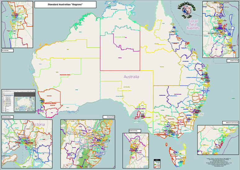
Free Standard Australian Regions Poster Map for Download
Give a few people a large Australian map showing state and territory borders, but otherwise blank. Ask each to draw the boundaries of a few major cities or regions (“The Illawarra” is usually interesting!) on the map. The results will probably be surprising – while there will be some similarities, there will be big differences. Our perceptions are very individual, and other than state and territory borders, there are few other rigid boundaries which we might think of as “fixed”. If you are confining your interest to a few cities or regions – very common – please download a copy of the map below, it’s the best reference to “standard regions” we’ve come up with to date!.
Our “Standard Regions and Region Names of Australia” map; it is poster size (B0) in universally readable Adobe PDF format (c.50MB download) and may be a useful reference when specifying your “area of interest”. Click the thumbnail map below and you will be redirected to our Hightail download page for the download link to the full-size map. Tech tip: this is a layer-enabled map showing standard regions separately at both large and smaller scales. Adobe Reader has a handy “layer” function to allow you to filter only data of interest – there is a “how to” screen shot included with the map – it’s just offshore from Perth (you can turn that off too, using the layers pane)! Update: we have added a text-searchable version of the map to allow you find regions you may know by name. The data is identical but the region labels are searchable using the Adobe Reader “find” tool – it doesn’t look quite as nice as the default map, but we thought some of you may like to have this option – why not download both and spoil yourself for choice! The text searchable version can be found at this link.
 A typical use of postcode area data to visualise distribution of customers or product sales *
Available as three versions in different sizes, for New South
Wales, and the smaller A4 one for Sydney.
Random Customers by Postcode sample NSW A0 Map
A3 layer enabled map for New South Wales
A4 layer enabled map for Sydney, New South Wales
If you’re unfamiliar with Adobe’s “layers” please also download this handy “how to” screenshot.
There are also postcode data samples to view in Google Earth:
Random Customers – Download the area (“polygon”) sample
Random Customers – Download the point (“map pin”) sample
Victoria Postcode Areas Sample 2010 geography with 2006 Census data (note this version uses the “skyscraper effect” based on 2006 total population).
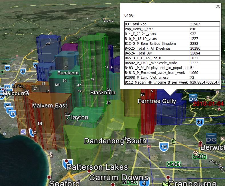
Postcode data showing “sky-scraper effect” based on census data from 2006.
Victoria Postcode Areas Sample 2023 geography. Access code for this file: MMPCP2023
Victoria Postcode Areas Sample 2023 geography with 2021 Census data. Access code for this file: MMPCS2023 (note this version also uses the “skyscraper effect” based on 2021 total population – witness the eye-watering, immigration-fueled population growth in just 15 years!)

Victoria – MapMakers Postcode Areas Sample 2023 data, Skyscraper effect based on population Census 2021
* Please note the data used in these sample products are generated and / or randomised, they are for illustrative purposes only and are not intended for practical application.
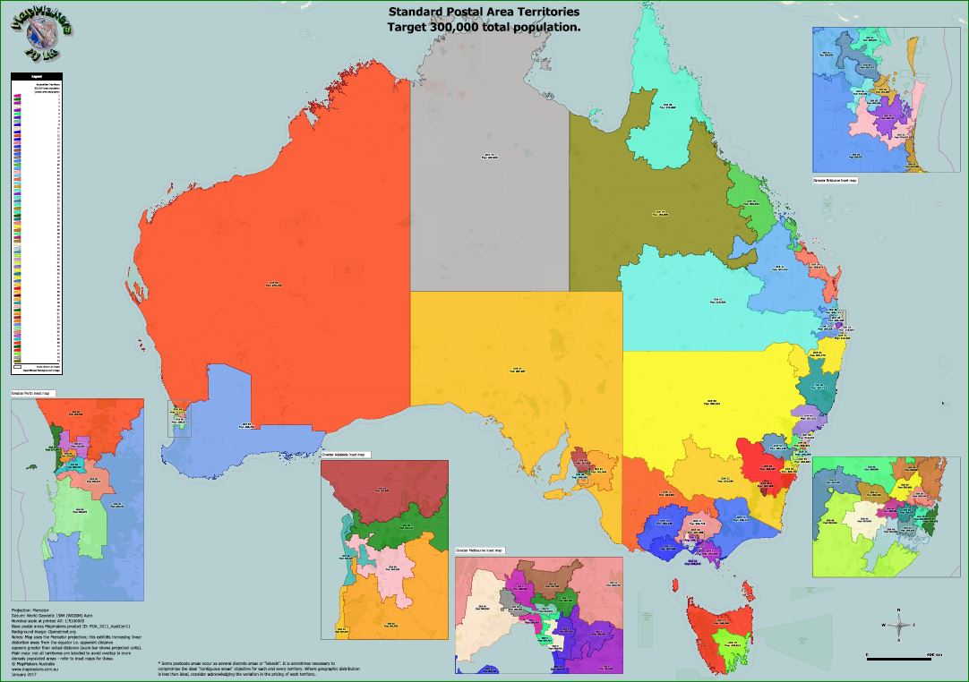
Australia Standard 300k Territory Map.
Territory maps are another popular product. This example illustrates how a “target” demographic is used to generate a series of exclusive territories. The objective was for as close to 300,000 total population in each as possible / practical. Poster size A0 digital PDF Standard Territory Map of 300,000 TPop300_A0 is $750 ex tax

Australia Standard 400k Territory Map.
A 400,000 version TPop400_A0 is $650 ex tax. Order direct from sales. Individual maps for each territory can be ordered as required prices starting at $50 ea.
Latest versions can be previewed and purchased here.
 This sample shows how a list (spreadsheet, ideally with street addresses) of store locations can be visualised to see how a target market is penetrated, using both area and a variety of point style representations.
A2 layer enabled map for Sydney, New South Wales
Sir/Madam, We are looking to establish approximately 250 individual territories across Australia for a business concept.Can you provide information on your capability and recsources. Thank you. John Barnett.
Hi John, one of our staff will reply direct with a more detailed reply. Meanwhile, you may find our Territorry Mapping page a useful starting point. Regards, Mapmakers support.