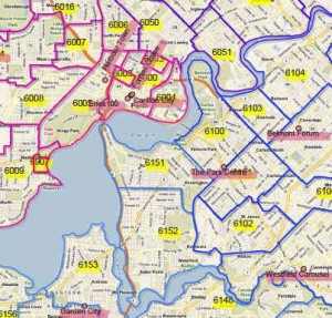
Postcode GIS Data Series
Examples of the GIS data series in use
Our Australian GIS Postcode Data products are available for individual States / Territories, and as a discounted compilation for our whole nation. They are available in just about all widely used modern and traditional digital GIS formats (GeoJSON, WKT, GML, ESRI .shp; MapInfo Mif/Mid; and KML for use with the amazing and free Google Earth – please see the Supplementary Licence Conditions for supply in Google KML format). These are suitable for a large range of advanced marketing and business analysis applications within a geographic information system (GIS) application. If you haven’t heard of GIS before, we have a Quick Introduction to GIS which you may find worth a look, in order to help you decide which of our products best meet your needs. GIS Data products are maintained regularly and are up to date for current 2024 Australian postcode revisions and updates. You Can see some examples of their use below. For users new to GIS and who would like some help getting started, you may be interested in our GIS software support options.
The following examples illustrate a number of approaches to creating, displaying and using postcode area geography in the context of territory or franchise mapping, we hope you find them informative!You can find an overview of things to take into account when planning such an exercise on the site here.
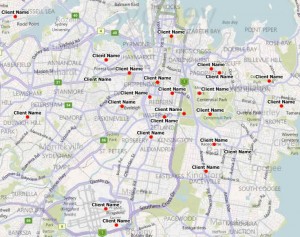
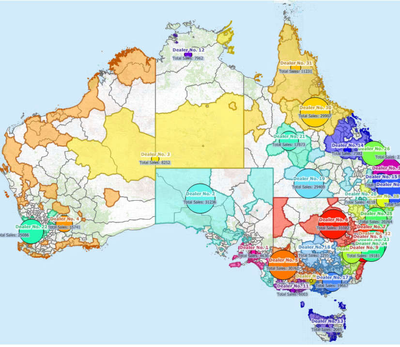
Seen here an illustration of our Postcode Area data deployed in a sales territory / franchise application.
Commencing with fifteen existing businesses, we have used their addresses including postcode, to automatically generate sensible territories for each, using adjacent postcode areas.
In this case we have used total area in square kilometres to best apportion territories. If we had other data, for example population density, mean income or other value of interest, we could have used one or more to create the territories.
You would require our GIS Data products to undertake such work yourself, and of course you will need a GIS application and the expertise to run it. Alternatively we can undertake such tasks for you. Please take a look at our custom mapping services section for an overview of custom mapping services.

In this example, postcode areas for New South Wales and the Australian Capital Territory have been assigned to twelve regions, each having, as close as possible, a similar number of homes (Census Enhanced version required) and each consisting only adjacent postcode areas
The size of the resulting regions varies greatly – relatively small areas in metropolitan Sydney to huge areas in outlying parts of the state. This reflects the density of housing. A franchisor would often modify the License costs of individual regional franchise areas to take into account variables such as travel or distribution costs, in addition to the variation in target numbers.
It is often possible to obtain a more even match of target numbers per region if we are prepared to accept that they will comprise both adjacent and remote postcode areas. For most businesses this is not desirable, but it is always an option.


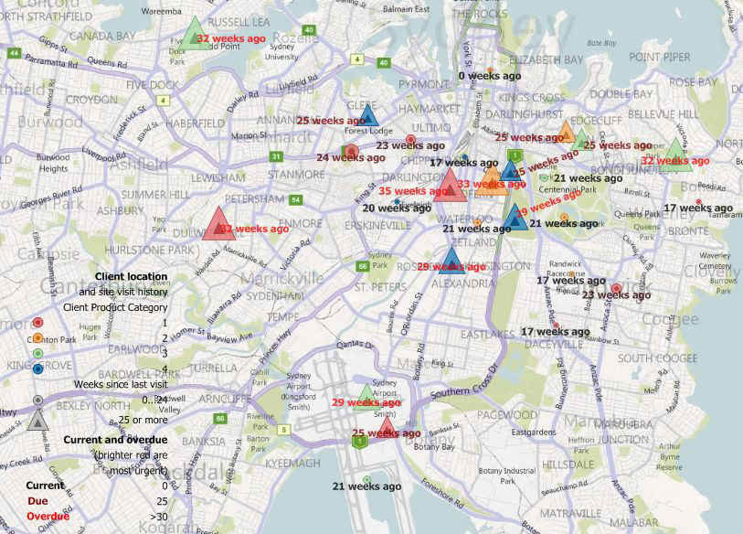
This allows us see all sorts of additional information. In this case (right) our customer is an agent for four manufacturers and likes to visit her clients at least every six months – 26 weeks. She can only travel safely with the merchandise of one manufacturer at a time. Here all her clients overdue a visit are shown as triangles, so it is evident that a group of four clients using manufacturer 4 products can be visited efficiently in a single trip as a priority.
“Business activity” may also be utilised. The following examples use the last ABS data on business activity available at postcode area level (an example of the current business count data is shown here).
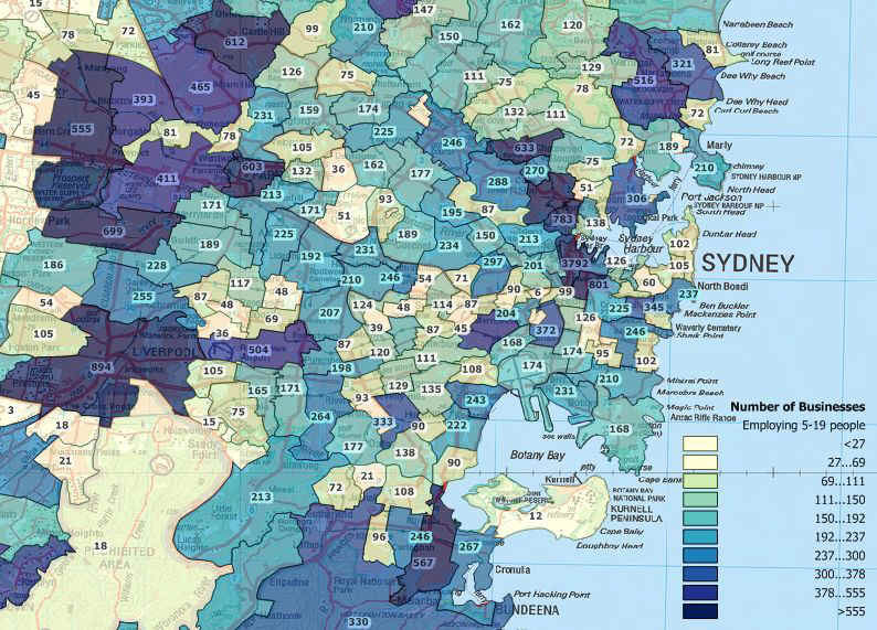
The map to the right shows the total number of businesses having at least one employee, for postcode areas around Sydney, NSW.

This map is the result of processing MapMakers Postcode area data PC002NSWACTDAT_Org to include the total number of employing businesses, and generate 9 sales territories, each of which has a similar (and thus fair) number of businesses in it. The numbers on the map show the total number of employing businesses in each territory based on the postcode areas within.
We can even analyse for trends in actively trading businesses over time, there is an example here.
As always, if you have your own in-house data relating to business activity of specific interest, or wish to compile such data from other independent sources, we could use that in a similar way.

For example a coffee machine leasing operator may feel that their most reliable and well priced machine is ideal for businesses with perhaps 20 employees (though probably too expensive a proposition for a sole trader – see two sections below – or really small firm). This map shows where such businesses, employing between 5 and 19 people, are distributed and how many are primarily located in each postcode.
The data could be used in a similar way to the Territory map above, to produce sales territories for potential franchisees.
This example combines both these types of data to map the distribution and number of businesses operating in the “Retail Trade” sector, but only those operations turning over less than $150,000 per annum.
Here’s a quick reference list of the default ABS “Industry Divisions”:
Agriculture Forestry and Fishing
Mining
Manufacturing
Electricity Gas and Water Supply
Construction
Wholesale Trade
Retail Trade
Accommodation Cafes and Restaurants
Transport and Storage
Communication Services
Finance and Insurance
Property and Business Services
Education
Health and Community Services
Cultural and Recreational Services
Personal and Other Services

There is also a category for “none employing” which can be taken to represent sole traders and other single person businesses.
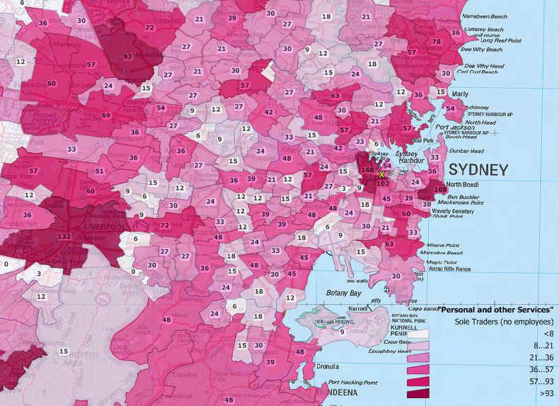
This map shows the distribution and numbers of such businesses operating in the “Personal and Other Services” sector from the default list reproduced above and for the same area as the four previous maps.
Of course if you are considering undertaking a territory mapping exercise using such data, it is important to feel comfortable with what the raw statistics are likely to represent. As with all ABS data, care is taken to protect the privacy of individuals and businesses, so the user must take some time to consider where the information of specific interest is likely to reside in the general statistics available.
In this map, the location of Kings Cross is marked with an “X”, but there are obviously many types of businesses which would be grouped together in the same very broad category of “Personal and Other Services”!
Note: The ABS has revised its standard geographical classification. Postcode level data is not available after 2007, with most recent business data (2023) compiled to new standard level, which is of only limited use for most territory planning work. We can restructure these data to a best approximation at postcode area level; this is a custom mapping task and is charged at standard rates. Contact sales with your requirements. We monitor ABS and other relevant site activity regularly and will continue to post updates as / when available (this information last updated February 2024).
This example demonstrates processed ABS business count data from 2011 and 2012, but analysed to postcode area level. The two sets of business counts are presented as percentage change from 2011 counts. The mean change for NSW plus the ACT over this period was +0.63%. Please note only random postcodes and values are shown in order to remove overlapping labels.
Note also the ABS data are four-year averages; data for 2014 includes data for the years June 2010 to June 2014 inclusive.
Immediately following is the most recent business activity data published 2014.

While a few postcode areas have maintained a positive trend in business activity over the period, the most recent data indicates a clear decline in overall business activity for the majority of postcode areas in the Greater Sydney region, with many previously growing postcodes slipping into decline (impacts from the GFC may be reflected in the data).
This is confirmed by the mean change in number of actively trading businesses over the whole of NSW plus the ACT – +0.63% growth in the previous period (above), but a negative -1.45% in this most recent data.
Making the same comparison for one of the nation’s unemployment black spots, we include the same analyses for northern Tasmania below.

Average number of actively trading businesses per postcode for the postcode areas visible in the map declined by -3.42%. The figure for all Tasmania over the period was a -2.5% decline.
The map below shows how the situation has changed over the four year reporting period twelve months later.

Average number of actively trading businesses per postcode for the postcode areas visible in the map declined by -5.14%. The figure for all Tasmania over the period was a -4.71% decline.
Sadly, while Tasmania is a beautiful island, enjoys an equable climate and is considered a great place to live and raise a family, there is a lot of truth in the saying “you can’t eat the scenery”!

We can make just about any style to match your corporate look. In this example, the aim was franchise areas based on postcodes which contain a population of resident women numbering between 20,000 and 30,000.
Your logo and any required corporate information can be included, either embedded in the map or supplied as separate documents.


It may be unnecessary to create / print individual territory maps with this approach, potentially saving a lot of money. There’s a summary of things most franchisers need to consider on this page.
These phone shots illustrate how it works (sorry about the quality, the phone usually takes the pictures!).


Here we have analysed the Census tables and assigned the total population of a particular age range and sex. The Postcode areas are then coloured on the basis of the numbers in the specified group: Dark green – high numbers; yellow – medium numbers; and red – low numbers.
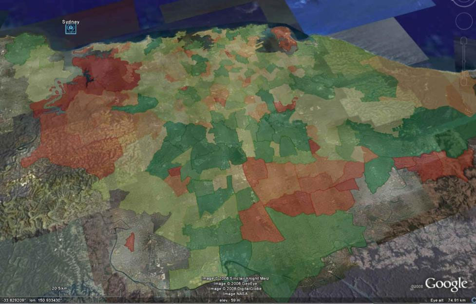

This is another example of the insights available through visualising data by geography, taking full advantage of the free Google Earth application!

This is the power of geographic data, turning your spreadsheet or database records into information which you can immediately leverage to advance your business.

Using the Data Series in Google Earth
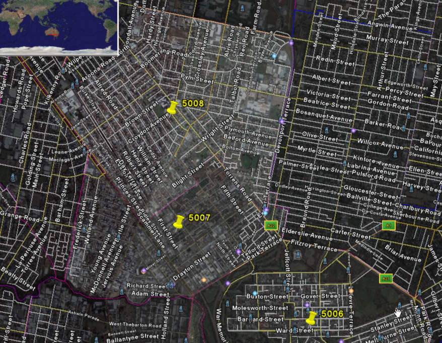
Owing to the “open” nature of the Google community, there is a Supplementary Licence Agreement required for supply of our Data Series in Google KML format. The License wording is illustrated here. This is the PC005SADAT product when deployed within Google Earth.. Our Postcode Area products will open immediately within Google Earth when requested in KML format. This view has placemarks added for Adelaide CBD, North Adelaide, Western Suburbs and Adelaide International Airport. Places of interest, facilities and a host of other location based information can be added – incredible!


While Google Earth and Maps are fabulous innovations (and free), you should be aware of some limitations which may affect how your objectives can be achieved through these applications alone.
First, the format used by Google (KML) is by default limited to two data attributes, plus an optional third (“height”) value for Google Earth only (this is how the “skyscraper” maps are created). We do have the capability to expand on this limit to some extent (see the postcode sample towards the bottom of our Census Data page for an illustration) – contact support if you require further details.
While we produce KML format for successful use in Google Earth, which is a stand-alone application, using the same KML files in Google Maps has some limitations over and above those of Google Earth, which is a script based application program interface intended for use from within a browser. For example there may be object size and complexity limitations for rendering in Google Maps, explained on Google’s site here. Some further restrictions on KML element support in Google Maps are also relevant as explained on Google’s site here. The image right shows our PC004VICDAT product uploaded to Google Maps, from where it can be deployed in a web site with relative ease (subject to our supplementary license agreement).
Please note: Owing to the “open” nature of the Google community, there is a Supplementary Licence Agreement required for supply of our Data Series in Google KML format. The Licence wording is illustrated here.
So great for display and fun to use, albeit with potential limitations especially in Google Maps, if you wish to engage in anything analytical using spatial data, it can only be achieved using a GIS application. Of course we can perform such analysis on your behalf and supply the processed results in KML format for you to use.
As Google say on their web site in relation to Size and Complexity Restrictions for KML Rendering in Google Maps: “Google Maps currently has specific limitations to the size and complexity of loaded KML files… Note: these limits are temporary and are subject to change at any time.”


